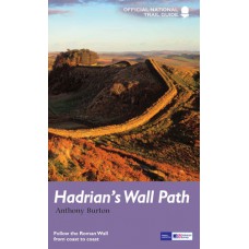
Hadrian's Wall Path
Official National Trail Guide
Since it opened in 2003 Hadrian's Wall Path has become one of Britain's most popular long-distance paths. Its 84 miles are a convenient week's walking, shadowing for the most part the historic line of Hadrian's Wall in its spectacular progress across the superbly wild landscape of the north of England. Starting in what used to be Tyneside's shipbuilding heart, and joining Newcastle in the east with Carlisle in the west, it takes you via the extraordinary Roman forts of Vindolanda and Housesteads, close to handsome towns like Hexham and Corbridge, to finish on the lonely shores of the Solway Firth with views of Scotland.
Comprehensive and engrossing, this official guide, published in conjunction with Natural England, is the only companion you need.
- Ordnance Survey mapping for the entire route
- Circular walks to major archaeological sites
- Background information on everything from archaeology to wildlife
- Comprehensive, up-to-date information on public transport, accommodation and places of interest
- Lavishly illustrated with colour photography throughout
| Book Details | |
| Title | Hadrian's Wall Path |
| Book Series | Official National Trail Guide |
| Author | Anthony Burton |
| Publisher | Aurum Press |
| Edition | Fully Revised and Updated Edition |
| Release Date | November 2016 |
| Language | English |
| Cover | Paperback |
| Map Details | Ordnance Survey mapping for the entire route |
| Printed Pages | 144 Pages |
| Size | 21cm x 13cm x 0.9cm |
| Postal Weight | 245g |
Hadrian's Wall Path | Official National Trail Guide
- Company: Aurum Press
- Product Code: AP-HWP-01
- Availability: In Stock
-
€16.95
- Ex Tax: €16.95

